


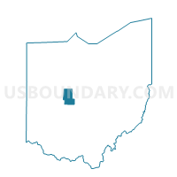
Voting District MARYSVILLE 6, Union County, Ohio
About
Outline

Summary
| Unique Area Identifier | 652892 |
| Name | Voting District MARYSVILLE 6 |
| County | Union County |
| State | Ohio |
| Area (square miles) | 0.28 |
| Land Area (square miles) | 0.28 |
| Water Area (square miles) | 0.00 |
| % of Land Area | 99.94 |
| % of Water Area | 0.06 |
| Latitude of the Internal Point | 40.23358180 |
| Longtitude of the Internal Point | -83.37364840 |
Maps


Graphs
Select a template below for downloading or customizing gragh for Voting District MARYSVILLE 6, Union County, Ohio


Neighbors
Neighoring Voting District (by Name) Neighboring Voting District on the Map
- Voting District MARYSVILLE 10, Union County, OH
- Voting District MARYSVILLE 2, Union County, OH
- Voting District MARYSVILLE 3, Union County, OH
- Voting District MARYSVILLE 5, Union County, OH
- Voting District MARYSVILLE 7, Union County, OH